Geofront System Engineering
It is now attracted a grate deal of attention to utilize underground space (Geofront) as the new space in order to preserve environment of geo-surface and urban surroundings and utilize them well. Considering environment and creating, conserving and maintaining underground space, we are educating students and researching on following themes:Research to explicate (dynamical and hydraulical) specific of soil, rock and water underground from the surface to deep underground and develop measurement technology for it.Geo risk management research to manage underground space considering specific uncertainty of soil and rock, social requirement and its cost.Research on complex problems combined above to solve complicated behavior of soil, rock and water.
Academic Staff
Hideaki YASUHARA
Professor (Graduate School of Engineering)
Research Topics
Contacts
Room 212, C claster 1, Katsura Campus
TEL: +81-75-383-3306
FAX: +81-75-383-3307
E-mail:
Hiromasa IWAI
Assistant Professor (Graduate School of Engineering)
Research Topics
Contacts
Room 211, C claster 1, Katsura Campus
TEL: +81-75-383-3306
FAX: +81-75-383-3307
E-mail:
Research Topics
Numerical simulations of soft ground using elasto-viscoplastic constitutive model
Coastal urban areas are at high risk for settlement and liquefaction because the ground consists of alternate layers of sand and soft clay layers. Modelling and evaluation of stress-deformation in the soft ground using soil-water coupled analyses are necessary for maintenance of infrastructures and disaster prevention.
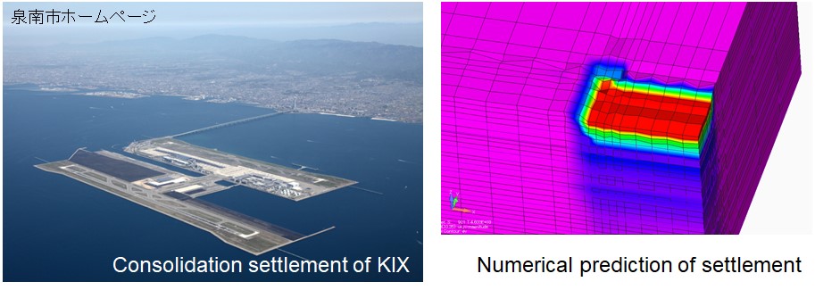
We aim to develop a procedure through finite element analyses that implements an elasto-viscoplastic constitutive model to study the problems in the coastal urban areas. This analysis was applied to the evaluation of long-term consolidation settlement in the Kansai international airport. We also deal with 3-dimentional problems such as the uneven settlement between the reclaimed island and the connection bridge.

Seismic zoning using geo-informatic database
Appropriate modelling of underground structures is necessary for accurate disaster assessment. We study 3-dimensional wide-area modelling of underground structures using geophysical exploration methods and borehole data, and implement disaster assessment with the developed underground model.
For the Osaka Plain, the dynamic response and liquefaction were numerically predicted for the 250 m square mesh model of the Osaka Plain, and the calculated results were displayed as a distribution map so that they could be used for disaster prevention policies.

Modelling of underground structures in the protected inland by levees and its application to assessment of seepage induced disaster
Assessment of disasters due to heavy rain and floods nowadays is becoming an important issue particularly for levees and the floodplain. We aim to develop 3-dimensional wide-area underground model using geo-informatic database to evaluate the seepage in the protected inland by levees.
The 3-dimennsional model of the protected inland of the Kizu River levees in Kyoto was created based on the geo-informatic database and laboratory-obtained permeability of each layer. We numerically predicted 3-dimensional seepage in the area using this model.

Mechanism of water transfers and control systems in the unsaturated ground
Seepage must be appropriately controlled because it reduces the stability of earth structures and promotes diffusion of contaminants in the ground. The hydraulic properties of soils greatly changes depending on water content. Water drainage and shielding systems have been studied based on laboratory tests on the hydraulic properties of unsaturated soils and numerical prediction of seepage in the ground.
A capillary barrier that occurs at the interface between the sand and gravel layers is a water shielding system using the hydraulic properties of unsaturated soils. We conducted rainfall tests and numerical analyses to observe capillary barriers. The results show that the difference between unsaturated hydraulic conductivity of the sand and gravel can be an important factor of the water shielding. We aim to develop methods for evaluating the water shielding capacity and designing capillary barriers. Evaporation as well as seepage contributes to hydraulic transfers in ground surface, which causes desiccation cracking and decrease in cohesion. We study methods for controlling seepage and evaporation based on the evaluation of deformation induced by water transfers in the unsaturated ground.

Rainfall induced instability of unsaturated earth structures
Unsaturated soils have bonding due to surface tension exerted on pore water, but the bonding reduces and deformation develops when rainfall infiltrates into the ground. Detail analyses on this process enables understanding the deformation mechanism and proposing appropriate countermeasures. Laboratory tests are conducted to obtain water retention and relationships between deformation characteristics. Then, deformation is numerically predicted by applying rainfall to the model created based on experimental results.
This method was used to restore the Sakafuneishi site in Asuka Village, Nara Prefecture, which is a historic site of the Asuka period (592 to 710 A.D.). The site was buried until it was excavated in 1999, and it has been openly exhibited. However, open exhibited geo-relics often damaged by precipitation. The seepage and deformation of the slope were numerically simulated. The results show that the slope failure occurred due to the reduction of the bonding between soil particles in the saturation process. The main factor of the slope failure is the very soft surface layer, and therefore we proposed replacing the surface layer with a well-compacted and highly permeable layer.

Mechanism of seismic damage of unsaturated earth mounds and its application to the protection of tumulus mounds
Earthquakes as well as precipitation give serious damage to unsaturated earth mounds. Tumulus mounds have been repeatedly damaged by earthquakes such as the past Nankai Trough Earthquake. Recently, serious damage due to the Kumamoto Earthquake in 2016 was reported. Understanding of the damage mechanism and developing the protection methods are required for the preservation of tumulus mounds.
We conducted dynamic centrifuge model tests and numerical analyses to study the damage mechanism. The results show that tensile cracks evolve in the tumulus mound, and the damage is significant due to stress concentration when the tumulus mound is constructed on a slope. We also found that the friction between the stones of the burial chamber greatly contributes to the seismic resistance of the burial chamber. Based on this knowledge, we aim to develop protection methods for tumulus mounds.

Laboratory Website
Geofront System Engineering (Prof. Yasuhara's Lab.)
